
By Khin Maung Myint
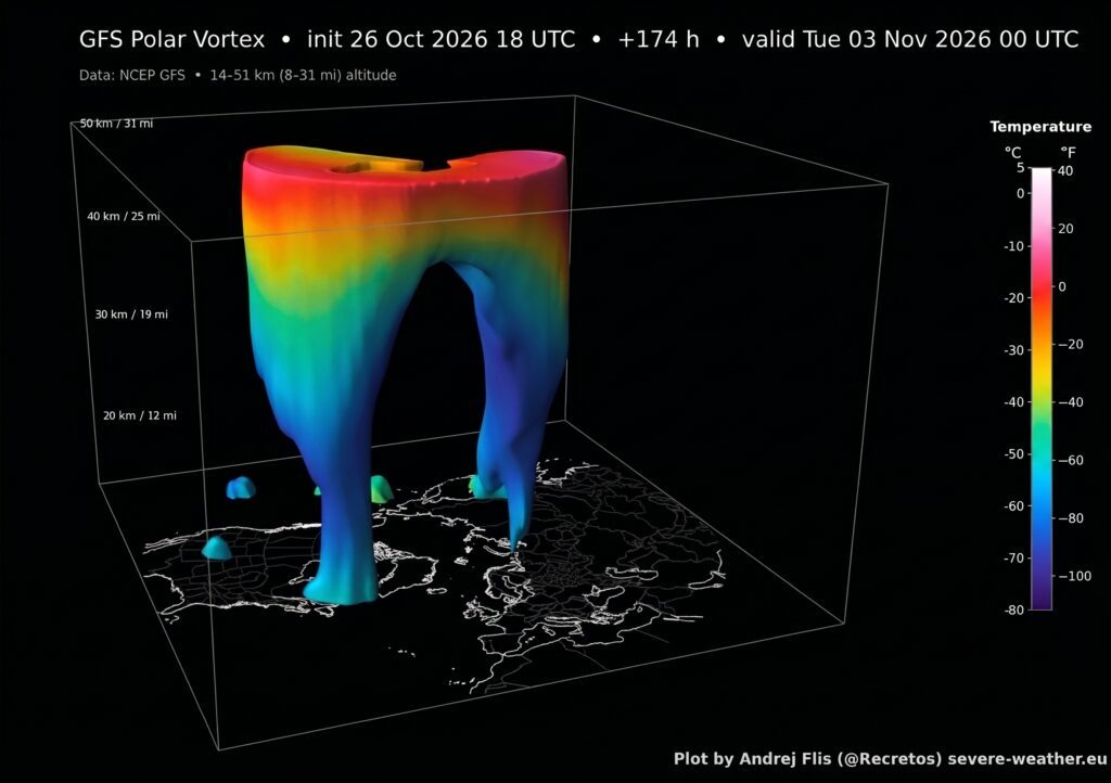
Weather computer models for early November 2026 are pointing toward an unusual event high above the Arctic: the polar vortex – the massive ring of icy air that usually sits over the North Pole – could break down and split into two separate cold pools. If this happens as early as mid-November, it would be the earliest atmospheric disruption of its kind ever recorded. While it sounds alarming, it does not mean instant doom. Instead, it acts like a wild card thrown into the weather system, shifting how cold air moves across parts of North America, Europe, and Asia as winter approaches.
1. What Is the Polar Vortex?
Think of the polar vortex as a giant, spinning top of freezing air trapped high in the sky – about 12 to 30 miles (20 to 50 kilometres) above the Arctic, up in a layer of atmosphere called the stratosphere.
Every autumn and winter, as the North Pole turns away from the sun and enters dark, icy conditions, this vortex forms naturally. When it is strong and working normally, it acts like a tight, high-altitude fence. Its powerful winds spin fast from west to east, locking the absolute coldest air on Earth safely up at the Pole. Under normal conditions in early November, this “atmospheric fence” is just building up speed and getting stronger ahead of deep winter.
2. Why Could It Split in Two?
Sometimes, big waves of heat and energy rise up from the lower atmosphere—pushed upward by warm oceans or massive mountain ranges like the Rockies and the Himalayas.
In late October and early November 2026, forecasters noticed a massive surge of this atmospheric energy heading straight for the Arctic stratosphere. When that energy hits the polar vortex, it acts like a sudden wedge jammed into a spinning wheel:
• The Winds Slow Down: The strong winds holding the cold air in place rapidly weaken or even reverse direction.
• Temperatures Skyrocket High Above: As air gets squished and trapped by high pressure up in the stratosphere, temperatures 19 miles high surge by 40°F to 50°F (22°C to 28°C) in just a few days. This sudden heat spike is called a Sudden Stratospheric Warming.
• The Vortex Pinches: Unable to stay in one circle, the ring pinches in the middle and ruptures into two smaller spinning hubs of cold air.
One of these new cold pools is expected to drift toward Siberia, while the second moves towards North America. Important Note: This dramatic warming happens 19 miles up in the sky. It does not mean that temperatures down on the ground will suddenly warm up by 40°F! Instead, it means the high-altitude fence holding the Arctic cold has broken down.
3. How Does This Affect Ground Weather?
What happens high in the sky eventually trickles down to where we live. This trickle-down effect takes about two to four weeks.
When the high-altitude polar vortex breaks apart, it messes with the jet stream – the high-speed “river of air” lower down in the sky (about six miles up) that guides day-to-day weather across the globe.
• A Bumpy Jet Stream: Normally, the jet stream blows in a relatively straight line from west to east. But when the vortex above it splits, the jet stream begins to buckle and bend like a snaking river.
• Escaping Arctic Air: As the jet stream dips far to the south, it creates open expressways for frigid polar air to leak out of the Arctic and pour down into regions that are usually much milder.
• Stuck Weather & Volatile Swings: A buckled jet stream tends to get “stuck.” This means some places might get hit with long spells of freezing weather, followed by sudden, unusual warm-ups when the winds shift.
4. Does This Guarantee an Extreme Winter Freeze Everywhere?
No. A split polar vortex creates the opportunity for severe cold snaps, but it does not guarantee historic blizzards everywhere. Two big factors determine what actually happens on the ground:
a. The Arctic “Cold Bank” Isn’t Full Yet
Because this disruption is happening so early in the season (early November), the Arctic has not had months of pitch-black polar night to build up truly extreme sub-zero cold. So even if the jet stream pulls air down from the north, that air mass might initially bring only moderately chilly weather rather than record-breaking blizzards.
b. The Battle with “Super El Niño”
Winter 2026-2027 is also being shaped by a strong Super El Niño in the Pacific Ocean. El Niño usually pushes mild, warm weather across northern regions of North America. This creates an atmospheric tug-of-war:
• Super El Niño tries to keep winter mild and smooth.
• The Split Polar Vortex tries to buckle the winds and drag down cold air. Which side wins will vary from region to region throughout November and December. 5. Why Is the Early November Timing So Unusual? Usually, the polar vortex breaks down in the middle or late part of winter – typically in January or February. A major breakdown in early November is essentially unheard of in modern satellite records. It breaks previous historical records by nearly three weeks! Because meteorologists have never seen a collapse happen this early in the autumn, computer forecasting models are dealing with more uncertainty than usual.
6. What Does This Mean Around the World?
Here is what different regions can expect as a result of the split:
• North America (US & Canada): While parts of Canada may stay milder overall due to El Niño, the Eastern and Central United States face a higher chance of sudden, sharp cold snaps heading into late November and December.
• Europe & the UK: The shift makes it more likely that high-pressure systems will park over Scandinavia or the Atlantic, blocking mild ocean air and allowing chilly continental winds to sweep across Northern Europe and the UK.
• Siberia & East Asia: Since one of the split cold pools is moving directly over Siberia, deep winter cold will build up early in Northern Asia, opening the door for periodic cold waves into China, Korea, and Japan.
• South-East Asia (Including Myanmar): Tropical regions are completely safe from polar vortex disruptions. Thanks to our distance from the pole and the towering mountain barrier of the Himalayas, Arctic cold air cannot reach mainland Southeast Asia. Myanmar’s cool season will simply follow its usual pleasant, dry pattern.
Summary: The potential polar vortex split in early November 2026 is a rare and historic atmospheric event. While it won’t trigger an instant deep-freeze everywhere, it reshuffles the deck for Northern Hemisphere winter weather, setting the stage for a volatile, unpredictable start to the 2026-2027 season. (Original content and atmospheric insight credited to social weather updates and AccuWeather forecasting analysis.)
#TheGlobalNewLightOfMyanmar