
Dr Kyaw (Meteorology School)
The transition of the monsoon season’s normally warm and humid weather to a slightly cooler and moister meteorological state, as the monsoon period nears its end, is a natural pre-indication that the region is preparing to enter the winter season. In regions located within the temperate zone of the Northern Hemisphere, such as China, Japan, Korea, and European countries, this temperature change is very distinctly felt. However, for regions like our Myanmar, which falls within the equatorial tropical zone, this change is not noticeably felt.
Nevertheless, this transition period is not a calm and gentle shift from one season to another. Instead, it is the most unstable period, where daily weather conditions can change rapidly (for example, sunny one moment and raining the next). For the Indochina Peninsula region (countries including Myanmar, Thailand, Laos, Cambodia, and Vietnam), the period from late September to the end of November can be roughly defined as the Post-Monsoon Season (or the Late Southwest Monsoon Period).
During this period, the weather events that can be encountered tend to be more severe and intense than normal, bringing significant challenges to people’s livelihoods, health, agriculture, and local economies. Particularly due to the consequences of global Climate Change, it is observed that the meteorological conditions of this post-monsoon period are becoming noticeably more intense and severe.
Myanmar’s Monsoon Rainy Season Cycle
The Indochina region, including Myanmar, is under the influence of the Northeast Monsoon and the Southwest Monsoon seasons. Generally, the pre-monsoon period begins around mid-May, the mid-monsoon period is from June to August, and September is the month when the southwest monsoon winds begin to retreat. According to research records, the months from October to November, before the Northeast Monsoon period begins, can be defined as the Post-Monsoon period.
During this period, the influence of the southwest monsoon on Myanmar diminishes, and it becomes a time when the country is more dominated by easterly wind waves from the east, as well as tropical typhoons. Furthermore, the northern regions of Myanmar also often experience the effects of westerly wind waves, which carry moisture from the Atlantic Ocean, travel across the Mediterranean region, and journey along the foothills of the Himalayas to the east.
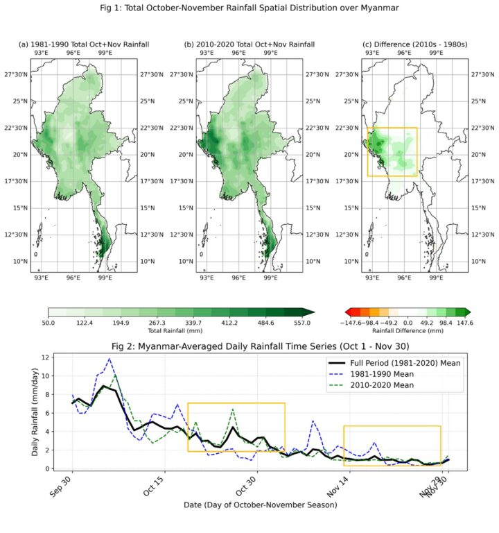
Changes in Post-Monsoon Rainfall in Myanmar
The presented maps compare the total rainfall of Myanmar’s post-monsoon period (i.e., the months of October and November) between the 1981-1990 decade and the 2010-2020 decade. According to Map (a), the regions receiving the highest rainfall are the already well-known Rakhine coast, the Ayeyarwady Delta region, and the Tanintharyi coast, while the central dry zone is seen to receive the least rainfall.
However, looking at the difference between the earlier 1990s decade and the post-2010 decade (Map-1-c), in the 2011-2020 decade, rainfall has significantly increased (shown in green) in many areas, including northwestern Myanmar (southern Chin State and northern Rakhine State), the Ayeyarwady Delta region, and the central basin region, including the Nay Pyi Taw Union Territory. At the same time, it was also found that rainfall has slightly decreased (red/orange) in some areas of the Tanintharyi coastal region.
According to the Temporal Plot of average daily rainfall, the country’s average daily rainfall during the 2010-2020 decade was higher than in the 1981-1990 decade (Figure 2). In particular, from mid-October onwards, the average daily rate of the most recent decade (green dashed line) is significantly higher than that of the 1980s decade (blue dashed line), indicating that the pattern of rainfall received after the end of the monsoon season reflects either more intense precipitation or more rainy days.
Untimely Rainfall
The main cause of the abnormal rainfall occurrences in the post-monsoon period is the increased frequency of suddenly forming cumulonimbus clouds, wind waves, and storm phenomena in recent years. The post-monsoon period is a time when winds transition from westerlies to easterlies. Storms and wind waves from the western Pacific Ocean, depending on their intensity, can also cause rainfall events by carrying moisture and clouds along with the easterly winds.
Similarly, the intense sun of the post-monsoon period, which might lead one to believe the rainy season is completely over, heats the ground during midday. The hot air in contact with this ground, which has accumulated moisture throughout the rainy season, rises rapidly and, due to physical processes, forms large cumulonimbus clouds (CB Clouds). These massive clouds cause post-monsoon rainfall events by generating lightning, strong winds, hail, and short periods of heavy rainfall.
Although these phenomena tend to occur in localized patches, their characteristically intense rainfall can cause sudden urban flooding in urban areas, and in rural areas, can lead to landslides and flash floods. Current research indicates that, alongside climate change, the frequency and intensity of these untimely rainfall events are increasing in many equatorial regions, including Myanmar.
The Threat of Storms in the Post-Monsoon Period
The phenomenon with the most dominant influence on the weather of the Indochina region during the post-monsoon period is typhoons from the South China Sea to the east. These storms, which form in the South China Sea and the northwestern Pacific, typically move westward or northwestward, affecting Vietnam, Laos, and even Myanmar.
On average, about 15 to 20 typhoons occur annually in the South China Sea, of which at least 4 to 6 usually make landfall on Vietnam’s coastline. Some of these storms occasionally reach the Andaman Sea and the Bay of Bengal. Although these storms weaken upon landfall, they can continue to cause heavy rainfall, leading to river overflows and landslides.
Similarly, in the Bay of Bengal during the post-monsoon period, cyclones and depressions occur more frequently than in the pre-monsoon period (April-May), but their intensity and likelihood of entering Myanmar are usually very low. However, studies indicate that with rising sea surface temperatures in recent years, the intensity of these storms is also likely to increase.
Flooding
Unpredictable, untimely rainfall can cause drainage systems to overflow and lead to floods in urban areas. Furthermore, heavy rainfall from cyclones can also cause rivers to overflow, submerging villages and farmlands. Delta regions and areas near rivers and streams in Myanmar are particularly prone to this hazard.
Recommended Preparedness and Protective Measures
To systematically face and overcome the above hazards, the following points are recommended:
Listen to weather news regularly. During the post-monsoon period, one should listen daily to the forecasts of the Department of Meteorology and Hydrology. If storm warnings or flood warnings are issued, people in coastal areas must be prepared to evacuate to safety.
Be cautious of flash floods. People living in low-lying areas, river valleys, and near watercourses must be especially cautious of flash floods. When it is raining heavily, one should avoid crossing deep water areas as much as possible.
Protect against lightning. When large cumulonimbus clouds are forming and during thunderstorms, do not stay outdoors in open fields, in water, or under trees. Take shelter inside sturdy concrete buildings.
Take special care of your health. To prevent illness due to temperature changes, one should eat foods that boost the immune system. In flooded areas, one should drink clean (or boiled) water to prevent water-borne diseases.
Farmers should prepare in advance to protect near-harvest crops from rain damage. Monitor weather forecasts daily and perform emergency harvesting if necessary.
Crop Selection and Scheduling:
Prioritize cultivating crop varieties that can be harvested at the end of the rainy season (e.g., early maturing paddy seeds).
Harvest timing should be planned based on weather forecasts.
Emergency Harvesting and Threshing:
If heavy rain is forecast, emergency harvesting should be done if there is time.
Harvested crops should be stored in a dry place, safe from rain.
Improving Field Drainage:
Regularly clean drains within fields to ensure good water flow.
Main drainage channels should be dug in advance to allow water to drain from fields quickly.
Providing Sturdy Support for Crops:
Use appropriate methods (e.g., tying rice paddies with ropes) to support crops and prevent lodging from strong winds.
Insurance and Market Research:
Purchase natural disaster insurance and familiarize yourself with the procedures for claiming compensation for losses.
Markets should be researched in advance to either immediately sell harvested crops or store them properly.
Conclusion
While the transition from one season to another is a beautiful part of nature, the post-monsoon period, due to its unstable daily weather patterns, requires us to be more vigilant and prepared. Research today indicates that due to global climate change processes, post-monsoon storms and untimely rainfall are becoming more frequent and potentially more intense than in the past.
Therefore, it is presented with the belief that by carefully listening to daily weather news and following the warnings of local authorities, we can safely overcome the meteorological challenges of the post-monsoon period.
#GlobalNewLightOfMyanmar